The HOA president started
The HOA president started fining me for cattle grazing on the ranch my family had worked for decades. I almost dismissed the first notice—until a strange parcel number sent me searching for a county map….
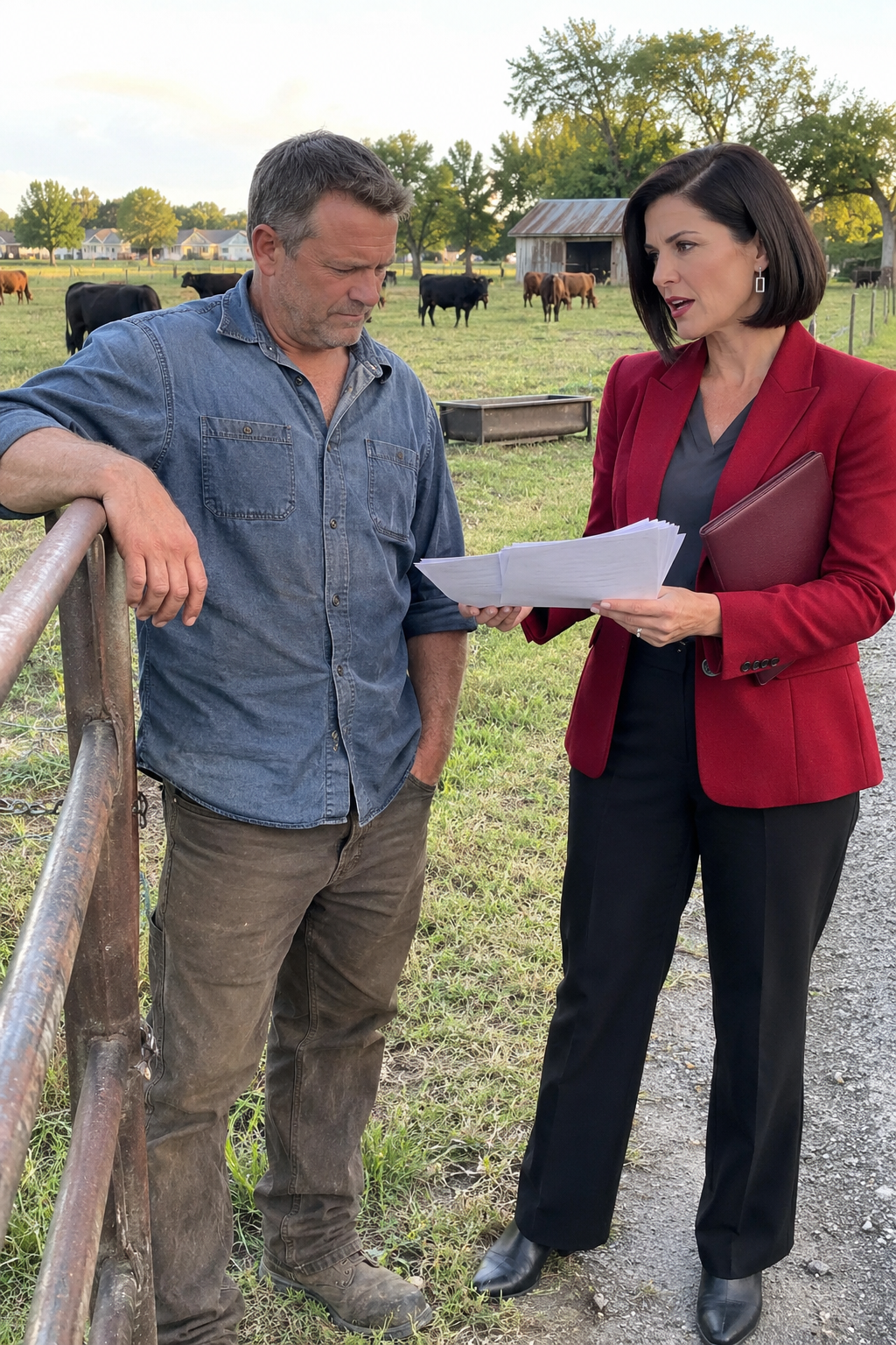
By seven that morning, Valerie Knox was at my cattle gate with a stack of papers tucked against her deep ruby-red blazer. Behind me, about thirty head of cattle were grazing across the north pasture. She was there to tell me the herd violated the neighborhood’s livestock rules, even though my family had worked that land long before the neighborhood existed.
My name is Nolan Greer. I was forty-seven when all this started, and I’d spent most of my adult life tending the same ranch my father worked before me. Three grazing fields, an equipment shed, an old barn, and a cattle gate on a narrow county road were pretty much the center of my world.
For years, the land beside ours was empty scrub and pasture. Then a developer bought several tracts south of us, put in streets, divided the ground into house lots, and eventually the homeowners organized an HOA. The houses were on the other side of a drainage swale and a line of cottonwoods. We were neighbors, but as far as I knew, we weren’t part of their subdivision.
I paid county property taxes. My land kept its agricultural classification. No one had ever asked me to join the association, and I had never paid HOA dues or signed an agreement forbidding cattle. Now, apparently, somebody had decided the rules applied to my pasture anyway.
Valerie was forty-six, tall and carefully put together, with a straight, nearly black bob and gray-green eyes that rarely gave anything away. She wore black trousers, pointed boots, small silver earrings, and that red blazer. A slim burgundy folio sat beneath her arm. She spoke with the measured certainty of someone who believed a board decision settled the question.
The first notice said I was keeping prohibited livestock. The second added a daily fine. The third warned that continued noncompliance might lead to collection measures. None of those papers concerned a noisy party or a neglected lawn. They concerned animals standing on land my father had fenced and cared for years before the first subdivision road was paved.
I looked over my shoulder at the herd. A few cows were standing near a feed trough; the rest were scattered along the grass. Nothing had changed in that field. Yet, according to Valerie’s paperwork, the animals had somehow become a neighborhood violation.
The fines weren’t enormous at first. That didn’t make them harmless. Daily charges could pile up, and a collection dispute could cost money even if the original claim was wrong. I wasn’t about to sell animals or hand over a check just to make an uncomfortable conversation go away.
I took the notices into my little office beside the equipment shed. There were feed invoices on one shelf, veterinary records in boxes, and my father’s old metal filing cabinet against the wall. The room still smelled faintly of machinery oil and old paper, and I could picture him sorting receipts at the same desk. I cleared a space and laid the HOA papers next to my latest county tax statement.
That’s when I saw it. The parcel number printed on the violation notice wasn’t my parcel number. It was close enough that I checked it twice, but one set of digits was different. I pulled my deed from the filing cabinet and checked again. My deed and county statement agreed with each other. The HOA papers didn’t.
I went through all three notices. The same unfamiliar number appeared each time. That made a simple one-time typing mistake seem less likely. Someone had built an enforcement file around a property reference that didn’t match the ranch where they’d photographed my cattle.
There were photographs attached to one notice, and the location in those photographs was unmistakable. I recognized the north fence, the feed trough, and the cottonwoods beyond the grazing field. The pictures showed my cows all right. But the number underneath those pictures appeared to refer to some other piece of land.
The next morning, I started digging through the older folders my father had left me. I found deeds, transfer papers from when he consolidated adjoining tracts, tax receipts, and records confirming the agricultural classification. The parcel number associated with the ranch stayed consistent through the newer records. The HOA’s number was still the odd one out.
I put everything in date order and compared the legal descriptions. My ranch was described by old survey points, bearings, and distances. The subdivision was described by newer lot lines and streets. I knew that being older than the neighborhood didn’t automatically protect me; land could be added to recorded restrictions later. I needed to find out whether that had actually happened.
I studied the county tax map. It showed my ranch as a broad tract along the road, with smaller residential lots to the south and southeast. When I looked up the HOA’s parcel number, it pointed toward land closer to the development entrance, not the main grazing field. I began to wonder whether they’d attached the right photographs to the wrong property.
That afternoon, I drove to the county records office carrying copies of the notices. It was the kind of place where people quietly searched property histories on public terminals. There was no audience to persuade and no board member to argue with, just the documents people had recorded over the years. I started with the number Valerie’s office had used. Its history led to development land that had once been part of a larger agricultural holding.
Then I searched my own parcel. The acreage, ownership history, and description matched the deeds I’d brought. I didn’t find a sale of my ranch to the developer or a record replating it into residential lots. That wasn’t conclusive—covenants could bind land without a sale—but it gave me reason to keep looking.
I opened the recorded subdivision plat. The roads and residential lots were familiar, and the boundary came into view around them. I also had a simplified neighborhood map from the HOA’s violation package. At first glance, the two seemed to tell the same story. I checked the street names, the bends in the road, and the southern line of trees so I knew I was comparing the same area.
Then I put the pages side by side. On the HOA map, the neighborhood’s northern edge appeared to push up toward my cattle field. On the county’s recorded plat, the boundary stopped south of most of that pasture. The two lines were not in the same place.
I checked the recording information at the bottom of the plat and found a reference to the subdivision’s declaration. The map was the first real break in the case, but it raised a bigger question: Had some later legal filing brought my pasture into the HOA after that plat was recorded? Part 2…..
The county plat gave me a boundary, but it didn’t yet tell me every restriction that might apply to the land. I went back to the archive and searched for the declaration named on the plat. If Valerie’s board had the right to regulate my cattle, somewhere in the recorded documents there ought to be a legal description connecting that right to my ranch.
I found the original declaration and read through the sections on membership, assessments, enforcement, and prohibited animals. The livestock rule was real. It prohibited certain animals on property subject to the declaration, with limited exceptions for domestic pets. But those last words mattered far more to me than the rule itself: property subject to the declaration.
Near the back was an exhibit describing the covered land through survey calls. I printed it and set it beside my deed and the county plat. The exhibit followed the original development tract. My ranch’s description followed an older, separate chain of title, and the boundary described in the exhibit appeared to stop south of my primary pasture.
I couldn’t quit there. An HOA could add property through amendments or supplemental declarations. I searched the recording index for every filing tied to the association, sorting them by date. Some altered architectural standards or assessment procedures. One added residential lots in a later phase. Nothing I’d seen so far included my ranch parcel.
Then I opened a supplemental declaration recorded several years after the original subdivision. Its exhibit described property north of the first set of houses, which made me uneasy. The developer really had expanded in my direction. I followed its survey calls, one at a time, against my father’s papers and the original plat.
That later phase took in more land, but the line still turned east before reaching the field where the cattle had been photographed. Its parcel references matched the new residential lots, not my ranch. What looked like one continuous neighborhood on Valerie’s map was actually a patchwork: original lots, later additions, common land, and private ground that had remained outside.
I began assembling a binder. One section held my current and older deeds, another the tax and agricultural records, and another the original subdivision plat. I added the declaration, its property exhibit, the supplemental filing, and every notice the HOA had sent. I wanted anyone who looked at the dispute to see the documents in order, rather than take my word for what a line meant.
Still, I searched again. I found an amendment and restatement recorded more than a decade after the original declaration. It referred to earlier filings and attached schedules of property. Some wording was broader than the original. I wasn’t going to assume that a familiar phrase meant the legal boundary had stayed the same.
One schedule mentioned an old tract description that resembled the way neighboring farmland had once been identified. The old parcel numbers were not identical to the modern numbers. Land had been split, sold, and renumbered over the years. I sat there longer than I care to admit trying to make certain I wasn’t overlooking a portion of my own ground.
At the bottom of that schedule was a reference to another amendment, recorded after my father transferred the ranch to me. I requested it. By page five, I reached a new property exhibit describing land north of the subdivision, and one of its calls ran toward an old survey monument mentioned in my deed.
For the first time, I could see a real possibility that the HOA had a claim to some portion of the pasture. A single monument could belong to the corner of two adjoining tracts, or a boundary could run in an unexpected direction. I couldn’t determine that from a familiar name on a page. If the line crossed my cattle field, the argument would change substantially.
Another notice arrived while I was working through those records. It listed accumulated daily fines, administrative charges, and a collection deadline. The board was escalating its case while I was still trying to determine whether the land was even covered by its rules. I saved that envelope too, copied the notice, and added the date to a timeline.
The paperwork showed something odd. Valerie’s office kept using the same incorrect parcel number on its notices, while the later recorded amendment used a different description based on survey boundaries. The board had photographs of my cows, but it had never shown me a recorded instrument that actually joined my field to its restricted property.
I traced the concerning amendment back to an older conveyance. Long before the houses were built, a broad agricultural holding had been divided. One tract eventually went to the developer. The other went through the ownership chain that led to my family. The shared boundary between them seemed to be the source of the confusion.
Then I found a separate recorded survey from that earlier division. The scan was faint, but I could make out the monuments and the line between the two tracts. Both my deed and the HOA amendment mentioned the same monument, but they left that point in different directions. The marker was a meeting place, not proof that the properties overlapped.
I printed the old survey and drove home. The following morning, I walked the southern fence line with the drawing in my hand. Near the county road, I uncovered one old monument; farther west, among rocks and old wire, I found a weathered metal survey cap. The line between them appeared to stay south of the cattle pasture.
That was encouraging, but it wasn’t a professional boundary determination. Old markers could be disturbed, and I couldn’t establish legal measurements by pacing along a fence. I needed someone independent to retrace the line—someone whose work would still mean something when the HOA reviewed it.
Part 3 Thomas Merik came out two days later. He was sixty-three, a licensed land surveyor with more than thirty years of experience working rural boundaries in the county. Lean, white-haired, and calm, he wore a khaki field shirt under a navy utility vest and carried the equipment he needed to check the old records against the actual ground.
I handed him everything: the family deeds, the subdivision plat, the declarations and amendments, the old survey, and the violation notices. I told him I didn’t want a drawing that merely agreed with me. I wanted the recorded boundary retraced accurately, whether I liked where it landed or not.
Thomas began with the documents. He followed the old agricultural split, the developer’s later tract, and the survey calls referring to the common monument. The two legal descriptions shared a corner but followed different boundary directions from there. What I’d feared was an overlap was looking more like a misreading of adjoining land.
Then we went outside. He independently checked the monument near the county road and searched for the weathered cap farther west. He measured between the points, checked the bearing, and compared the positions with the historic survey. The line matched the older record closely, and it ran south of the area where my cattle were grazing.
The feed trough photographed by the HOA was north of that line. So was the stretch of fence in its pictures. The survey didn’t slice through my field or put any part of the photographed herd onto association-controlled property. It separated the expanded development tract from my ranch just as the older deeds described.
We kept walking and checking additional corners. One marker took time to locate in the brush, but the surrounding measurements supported the same boundary. Thomas didn’t treat my fence as proof; he relied on the monuments, recorded descriptions, and field measurements. That was exactly why I’d hired him.
A few days later he delivered the finished survey drawing. The original plat, later amendment, historic survey, and his retracement agreed on the crucial point: the pasture named in the HOA notices was outside the land covered by the association’s recorded property descriptions. Even the amendment that had frightened me ended up showing where the developer’s tract stopped.
I assembled a final evidence package with a deliberate order. First came the violation notices and their repeated wrong parcel number. Next were my deed and tax statement, followed by the county plat, the original declaration and exhibit, the supplemental declaration, the later amendment, the historic survey, and Thomas’s licensed survey drawing.
I included a written request to review the account and halt collection action while the property question was examined. Then I sent the package to both the HOA management address and the board’s official correspondence address. After that, I went back to feeding cattle and keeping the ranch running. The cows were never the ones confused about where they belonged.
For several days, nothing happened. The online account still showed a balance, and no one withdrew a single charge. Then an acknowledgment arrived saying the property issue had been referred for further review. It wasn’t a victory, but it told me the board was finally looking beyond the livestock rule to the documents that defined where that rule applied.
A week later I saw Valerie standing on the subdivision side of the southern fence. She had the same deep ruby-red blazer, neat dark bob, and burgundy enforcement folio. Several survey stakes were visible in the grass between us. She looked composed, but the stakes marked a line very different from the one shown on the simplified HOA map.
I took photographs of the stakes, the feed trough, and the section of fence visible in the HOA’s pictures. The strange thing was that the HOA’s photographs had always been accurate about the animals. The cattle were mine. The trough was mine. What was wrong was the claim that the association’s recorded restrictions governed the ground underneath them.
More daily charges appeared on the account, even after management received the survey. That bothered me, so I added those dates to the timeline too. The longer this went on, the less it looked like a routine rule violation and the more it looked like an error in how the association identified property.
A second letter eventually arrived. This time management said collection activity was temporarily suspended while the documents were under review. The fines remained listed, but the escalation had stopped. I didn’t celebrate. I filed the letter with the others and kept a copy beside the survey.
Final The answer finally came in an ordinary envelope from the HOA management company. I opened it at the ranch office, expecting another procedural update. Instead, the first page identified my parcel correctly for the first time in the entire dispute.
Management had reviewed the original declaration, the supplemental filings, the later amendments, the property exhibits, and Thomas’s survey. The conclusion was direct: the pasture where the livestock photographs were taken was not property subject to the HOA’s livestock restriction. The cattle violations were being withdrawn, and the enforcement balance would be corrected to zero.
The letter also confirmed that collection activity would not resume over those notices. No lien would be pursued based on the cattle fines. I read it again and laid it beside the first stack of violations Valerie had delivered. Same pasture, same cows, same fence. The association had finally corrected its understanding of the property.
The management company’s explanation went back to the wrong parcel number I’d noticed on day one. Someone had pulled a reference from an internal neighborhood map and account system. That reference belonged to development land near my ranch, not to the ranch itself. Each later notice had copied the same mistake from the first enforcement file.
I appreciated having an explanation, but it didn’t erase the weeks of charges and warnings. The correction letter said the violation history would be cleared and the association’s internal boundary references updated. That part mattered. I didn’t just want this month’s fines removed. I wanted the next board to know it couldn’t start the same argument with another misplaced line on a map.
A few days later I logged into the account and saw the balance at zero. The cattle violations and collection notation were gone. I printed that ledger and put it in the back of my binder, after the survey and the letter withdrawing the notices. A file that had begun with accusations now ended with the association’s own correction.
Valerie remained HOA president. There wasn’t a shouting match at the gate or a meeting where she was publicly embarrassed. About a week later, I saw her near the southern boundary, still wearing that ruby-red blazer. The survey stakes were visible, and she stayed on the subdivision side of them. I was content to leave it there.
Management later replaced the simplified boundary reference used for enforcement with information tied to the recorded parcels. My ranch was no longer treated as part of the area subject to the livestock restriction. That change was quiet, but it was the kind of quiet change that might prevent another person from getting notices they never should have received.
I never moved the cattle, sold part of the herd, or paid the fines. I didn’t need to argue that ranching was more important than the way the subdivision wanted to look. The HOA was allowed to have rules for the land legally covered by its declaration. The question was whether my pasture was part of that land, and the recorded documents said it wasn’t.
By early fall, life had settled back into its usual rhythm. Cattle moved between the north and west pastures. Feed trucks came through the same gate. Cars passed through the subdivision beyond the cottonwoods. Every now and then I’d spot one of those old survey caps near the southern line and remember how much depended on it.
No single paper had settled everything. My deed matched the county records. The historic survey matched the monuments. The licensed retracement matched the recorded amendments, including the one that had worried me most. Together they showed where the association’s authority ended, and every later charge lost its foundation.
I still keep the binder in my father’s metal cabinet. It reminds me how easily a wrong number can become an official-looking demand when nobody checks the underlying record. The cows never knew a dispute was happening. They kept grazing exactly where they always had, and in the end, that was where they stayed.
THE END. I’ve shared the complete story, and I truly hope it touched your heart. If this story moved you, please , like, and share the post. Thank you for reading! ❤️
✓ Lynn R. Adams
The HOA president started fining me for cattle grazing on the ranch my family had worked for decades. I almost dismissed the first notice—until a strange parcel number sent me searching for a county m…